
No products in the cart.
GeoCue True View 515
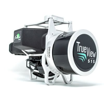
The True View® 515 is GeoCue’s latest addition to our LIDAR/camera fusion platform designed from the ground up to generate high accuracy 3D colorized LIDAR point clouds. Featuring dual GeoCue Mapping Cameras, Hesai PandarXT-32 laser scanner and Applanix Position and Orientation System (POS), the result is a true 3D imaging sensor (3DIS). With its wide 120° fused field of view, the True View 515 provides high efficiency 3D color mapping and will redefine LIDAR wire extraction and dense vegetation penetration applications for all- purpose grade sensors.
Drone LIDAR/Imagery Sensor Fusion, by Design
The True View® 515 is GeoCue’s latest addition to our LIDAR/camera fusion platform designed from the ground up to generate high accuracy 3D colorized LIDAR point clouds. Featuring dual GeoCue Mapping Cameras, Hesai PandarXT-32 laser scanner and Applanix Position and Orientation System (POS), the result is a true 3D imaging sensor (3DIS). With its wide 120° fused field of view, the True View 515 provides high efficiency 3D color mapping and will redefine LIDAR wire extraction and dense vegetation penetration applications for all- purpose grade sensors.
Two GeoCue Mapping Cameras provide a 120° field of view, coincident with the laser scanner track. The 25° oblique mounting ensures the sides of objects are imaged, allowing a true 3D colorization of all LIDAR points.
A Google® Coral TensorFlow Processing Unit provides exceptional power as the True View central controller. The CCU coordinates all on-board functions of the system.
A sensor can be no more accurate than the position and orientation system. GeoCue incorporates the industry’s most accurate and reliable POS – the Applanix APX series. APX post-processing is accessed via the included True View software, providing “pay-as-you-go” access to SmartBase and Trimble PP-RTX positioning services.
Post-processing software uses positioning system information to perform roll compensation at the individual scan line level. This allows reduced overlap between flight lines, increasing platform flight efficiency.
Fusing sensor data requires exceptional timing synchronization among the positioning system and all sensors. True View’s System Synchronization Unit (a GeoCue designed Master Clock), ensures sensor coordination at the microsecond level.
Product Specifications
| Lidar Scanner | Hesai PandarXt-32 |
| Lidar Range- Usable | 80m @ 20% Reflectivity |
| Cross-track FOV/Combined | 120° |
| LiDAR Beams/Returns Per Beam | 32/2 |
| Pulse Repetition Rate | 640 KHZ |
| Network Accuracy | Better than 5 cm RMSE |
| Precision | Better than 5 cm at 1 σ |
| Dual Cameras(Port, Starboard) | ±25° cross-track oblique |
| Camera Sensor | Sony 1″ CMOS IMX-183 |
| Camera Lense | 28 mm ƒ, 2.8 Max F Stop, fixed focus |
| Camera Cross-track FOV | 63.8° |
| Camera Trigger | Interval or Distance |
| Mass | 2.25kg |
| Operating Time(per battery) | >1 hour |
| Dimensions | 130.5 cm x 17.5 cm x 16.7 cm |


